During the colonial era, the British and other colonial powers used place names and urban symbols to control African territories. In Kenya, particularly in Nairobi, this tactic became common in the late 1800s.
In the early days of colonial Nairobi, the city was home to three main groups: the British, Asians, and indigenous Africans. Although Africans made up the majority, they had the least social, economic, and political influence.
African names were rarely used in the city, a move meant to marginalize the native population. The colonial authorities ensured Africans had little control over city affairs.
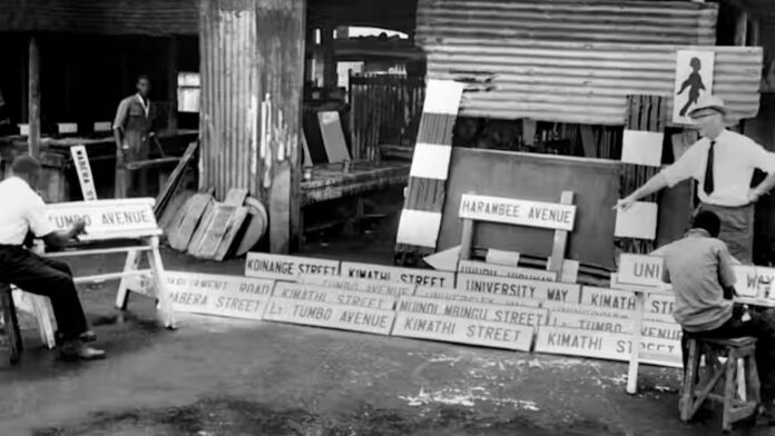
Colonial street names filled the city centre, while African names were pushed to the outer residential areas.
The 1948 Nairobi Master Plan emphasized a containment strategy meant to prevent opportunistic immigration into Nairobi and regulate access to urban resources.
There were 642,000 Africans compared to just 10,400 Europeans in 1944. However, the British, the smallest group, had most of the power and actively shaped Nairobi’s identity.
This was clear in how the city’s streets, buildings, and parks were named and arranged, ignoring its pre-colonial roots. Most names honoured British royalty, colonial leaders, settlers, and prominent Asian figures, with little acknowledgement of pre-colonial Kenya.
The way the city was organized led to segregation with labels such as European Bazaar, Subordinates’ Quarters, Coolie Landhies, and Indian Bazaar being used. At first, these terms described space divisions, but they became official place names over time.
This article looks at how Kenya continues to reflect a British blueprint that was intentionally implemented in urban areas. Simple naming conventions permanently changed Nairobi.
These names were used to show political, ideological and ethnic dominance of the British colonial government.
1. City Pioneers
The ‘true pioneers’ of colonial Nairobi were the British authorities, settler farmers, businessmen, and railway workers. The top administrative role was commissioner but later became governor.
Arthur Henry Hardinge was Kenya’s first British governor (1895-1900), then followed by nearly 30 others. Streets and parks were named after these governors and prominent settlers, like Lord Delamere and Karen Blixen.
In 1952, during the State of Emergency over anti-colonial resistance, Sir Philip Mitchell was the governor. After he stepped down, Mitchell Park on Ngong Road was named after him, but it has since been renamed Jamhuri Park.
Some colonial names that have been replaced in Kenya include Sadler Street (Koinange Street), Elliot Street (Wabera Street) and Hardinge Street (Kimathi Street).
Africans were mostly assigned manual jobs and temporary housing in Nairobi. However, some were honoured with street and place names, including Eliud Mathu (Kenya’s first African Legislative Council member), Argwings Kodhek (the first African lawyer), Harry Thuku (an activist), and Tom Mboya (a workers’ rights advocate).
How popular towns in Kenya got their names; meaning behind these names
2. Street names honouring British political hierarchy
On several occasions, members of the British Royal family visited the Kenya colony. The first visit was by the Duke of Connaught and his family. Afterwards, a street was named after him.
Subsequently, many streets in Nairobi were named after royals. For example, Princess Elizabeth Way, Victoria Street, Kingsway and Queensway. They were complemented by colonial statues such as King George’s and Queen Victoria’s.
One such monument for Queen Victoria was unveiled in Jeevanjee Park, which was named after Indian businessman Alibhai Mulla Jeevanjee. He was responsible for donating this statue as a sign of his allegiance to the monarchy and the British powers.
3. Areas named to recreate ‘Home away from Home’
Recreating a home away from home was a challenge to many officials. The British masters were not comfortable with local place names. They resorted to naming streets in Kenya after towns, villages and regions in the UK.
Some of these names have lasted in the Nairobi landscape for decades. They include Hurlingham, Lavington, Riverside, Spring Valley, Westlands, Parklands, Rosslyn and Highridge, among others.
4. Railway depot and Campsite nomenclature & numbering
Indian labourers referred to as ‘coolies’ at the time, built the railway line connecting Mombasa port to Uganda. By mid-1899, the railway reached Nairobi, a swampy area where the Maasai once grazed their cattle.
Nairobi became a temporary railway depot and soon became a permanent settlement were set up. A station and housing were built for railway officers, workers, and Indian labourers in Coolie Landhies, with separate areas based on rank and race.
The 1899 Uganda Railway Plan for Staff Quarters showed that the only roads with real names were Station and Workshop roads. All the rest were numbered streets or avenues.


